

• WHO WE ARE
  • CONTACTS
  • PARTNERS
  • ADVERTISING
  • NEWSLETTER
Friday, September 25, 2026
BlueLifeHub
  • Home
  • News
  • Fishing
  • Aquaculture
  • Environment
  • Players
  • Innovation
  • Events
  • Integrated Activities
No Result
View All Result
Blue Life Hub
  • Home
  • News
  • Fishing
  • Aquaculture
  • Environment
  • Players
  • Innovation
  • Events
  • Integrated Activities
No Result
View All Result
Blue Life Hub
No Result
View All Result
Home Innovation

After 450 years of the Mercator Map, the UN says it’s time to see Africa at its true size

A landmark UN resolution is challenging one of the world’s most familiar maps, calling for a fairer representation of Africa and its true dimensions.

Orazio Albano by Orazio Albano
September 15, 2026
in Innovation, News
Reading Time: 3 mins read
0
After 450 years of the Mercator Map, the UN says it’s time to see Africa at its true size

After 450 years of the Mercator Map, the UN says it’s time to see Africa at its true size –

For more than four centuries, the Mercator map has shaped the way millions of people see the world. Now, the United Nations is calling for a change.

On September 4, 2026, the UN General Assembly overwhelmingly backed a resolution promoting maps that represent the relative size of continents more accurately, with a particular focus on Africa. The resolution passed with 164 votes in favour, one against and six abstentions.

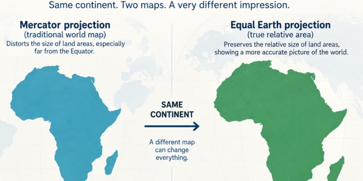
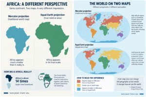
At the heart of the debate is a striking geographical reality: Africa is far bigger than it appears on the traditional Mercator map.

The clearest example is Greenland. On a Mercator map, Greenland can appear almost comparable in size to Africa. In reality, Africa covers more than 30 million square kilometres, compared with Greenland’s 2.2 million.

Africa is about 14 times larger.

The distortion comes from the way the Mercator projection works. Created by Gerardus Mercator in 1569 for maritime navigation, it preserves angles and directions but increasingly exaggerates land areas towards the poles.

As a result, Greenland, Canada, Russia and northern Europe appear disproportionately large compared with regions closer to the Equator, including Africa.

The map does not technically shrink Africa. It enlarges high-latitude regions around it, dramatically altering our perception of their relative size.

Equal Earth puts Africa back in proportion

The UN resolution supports greater use of equal-area projections, including Equal Earth, when the objective is to show the true relative dimensions of the world’s regions.

Developed in 2018, Equal Earth preserves the proportional area of countries and continents. And the difference is immediately visible.

Africa suddenly looks huge.

Not because the new projection makes it larger, but because it shows its area in the correct proportion to the rest of the world.

At approximately 30.37 million square kilometres, Africa is the second-largest continent on Earth. Its scale is difficult to grasp from the map many of us grew up with: the United States, China and India could fit inside Africa together, with millions of square kilometres still remaining.
The initiative behind the UN resolution, promoted by Togo on behalf of the African Group and supported by the African Union, argues that this is not only a question of cartographic accuracy.

Maps influence how generations understand the world.

A representation repeated in classrooms, books, media and digital platforms eventually becomes part of our mental geography. For Africa, that has meant centuries of appearing smaller in relation to northern regions than it actually is.

The UN is not banning the Mercator projection. It remains an important map for navigation, the purpose for which it was originally designed. The resolution instead calls for more appropriate projections when maps are used to compare the size of countries and continents.

That distinction is important: there is no perfect flat map of a spherical planet. Every projection involves a compromise.

But if the question is how much space a continent actually occupies on Earth, an equal-area map offers a very different picture.

And nowhere is that difference more powerful than in Africa.

More than 450 years after Mercator drew his famous map, the UN vote is asking the world to reconsider an image it has long taken for granted.

Africa has not become bigger. We are simply beginning to see how big it has always been.

After 450 years of the Mercator Map, the UN says it’s time to see Africa at its true size
Tags: africaAfrican UnioncartographyEqual EarthGeographyMercator MapUnited NationsWorld Maps
ShareShareTweetSend
Previous Post

Interview with Faith Mwende & Collins Nyamu, Co-Founders, Sea Ventures Kenya

Next Post

Tanzania: Aquaculture at the Gateway to Africa’s Blue Transformation

Orazio Albano

Orazio Albano

Independent consultant, in aquaculture and Blue Food value chain, with over 19 years of experience in technical support to cooperation projects, and consultancy to private companies, in Italy, Norwey, Ghana, Greece, Albania, Republic of Congo, Angola, Somalia, Tunisia, Turkey, Egypt, Morocco, Libya, Kenya. Co-founder of the Facebook group Coastal Community Network.

Related Posts

Are orcas really attacking boats? What science tells us

Are orcas really attacking boats? What science tells us

by Editorial staff
September 25, 2026

Are orcas really attacking boats? What science tells us - For several years, an unusual interaction between humans and one...

When the sea changes, so does the menu: Fish Very Good in Trieste, Italy

When the sea changes, so does the menu: Fish Very Good in Trieste, Italy

by Douniazad Abbani
September 23, 2026

When the sea changes, so does the menu: Fish Very Good in Trieste, Italy - The name Fish Very Good...

A new practical framework for rainbow trout welfare in seawater aquaculture

A new practical framework for rainbow trout welfare in seawater aquaculture

by Editorial staff
September 22, 2026

A new practical framework for rainbow trout welfare in seawater aquaculture - Fish welfare is becoming an increasingly important component of...

Connecting the Ocean: how WSense is building the underwater wireless internet

Connecting the Ocean: how WSense is building the underwater wireless internet

by Editorial staff
September 21, 2026

Connecting the Ocean: how WSense is building the underwater wireless internet - We are surrounded by connected devices. On land,...

Next Post
Tanzania: Aquaculture at the Gateway to Africa’s Blue Transformation

Tanzania: Aquaculture at the Gateway to Africa’s Blue Transformation

Leave a Reply Cancel reply

Your email address will not be published. Required fields are marked *

Categories


Newsletter

Blue Life Hub

The goal of Blue Life Hub is to inform and network between players in the Mediterranean and Africa, areas that have very important commonalities and shared interests.

Categories

  • Fishing
  • Aquaculture
  • Environment
  • Players
  • Innovation
  • Events

Follow us on:

Stock images by Depositphotos

  • WHO WE ARE
  • CONTACTS
  • PARTNERS
  • ADVERTISING
  • NEWSLETTER

© 2025 BLUE LIFE HUB. - P.Iva: 06325260823

Welcome Back!

Login to your account below

Forgotten Password?

Retrieve your password

Please enter your username or email address to reset your password.

Log In

Add New Playlist

Our Spring Sale Has Started

You can see how this popup was set up in our step-by-step guide: https://wppopupmaker.com/guides/auto-opening-announcement-popups/

No Result
View All Result
  • Home
  • News
  • Fishing
  • Aquaculture
  • Environment
  • Players
  • Innovation
  • Events
  • Integrated Activities
  • Who We Are
  • Contacts
  • Partners
  • Advertising
  • Newsletter

© 2025 BLUE LIFE HUB. - P.Iva: 06325260823